BESST: A microbolometer with onboard calibration
Introduction
BESST is the Ball Experimental Sea Surface Temperature instrument. It’s a FLIR microbolometer operating between roughly 8 and 10 micrometers. It has two onboard blackbodies used to calibrate the array in situ. A stepper motor spins a mirror to change the field of view to one of four orientations. The goal of the instrument is to map sea surface temperature to better than 0.2 Kelvin in a lightweight assembly capable of flying in unmanned aerial vehicles.
This unit led to CIRiS, Ball’s first CubeSat. CIRiS was released from the space station in the spring of 2020. In turn, CIRiS led to L-CIRiS, an instrument flying to the moon using the same concepts.
The first image shows the as-built BESST unit. You can see from the connector at top that this is a small instrument.

The concept behind BESST is simple:
- Microbolometers are noisy, they drift, and each pixel must be calibrated
- Let’s solve these shortcomings with frequent onboard calibration
In BESST, one blackbody is heated and the other drifts with the ambient temperature. A stepper motor rotates a mirror to view the blackbodies about every minute to capture a sequence of frames. After a flight, these frames are used to fit a linear equation to back out correction terms for each pixel.
BESST was built to measure sea surface temperatures for Dr. Bill Emery at The University of Colorado at Boulder. To do this accurately, you must subtract off the solar and atmospheric contributions so there is a zenith port to capture views opposite the ocean.
The next image is an exploded view showing how the blackbodies (labeled Calibration) face a central cavity housing a rotating mirror. Two baffles to the outside world provide zenith and nadir views.

Work Overview
I started as an emergency programmer and eventually took on ownership of a control software rewrite, the data analysis packages, and provided field and airborne support. I also extensively supported the CIRiS mission as both an infrared expert and general systems engineer.
The original software used FLIR’s graphical user interface and relied on a script that simulated keyboard strokes like “TAB” or “ENTER” to start and control the system. It was written by a graduate student of Dr. Emery’s and did okay unless anything went wrong. Bill Good was the Ball manager in charge of BESST and he had heard I knew about programming. Even though I was a structural engineer, he asked if I might be able to help out. I was ready to expand my aerospace knowledge and agreed to help.
Over time, I ended up developing a new GUI built in C# that worked with FLIR and Arduino software libraries to control and read the camera, heaters, temperature sensors, and motor. We ran it all on a micro-PC sized to fit in a UAV. The whole thing can be operated with a single button push or controlled via the GUI. The code featured parallel threads because the motor took time to turn yet there were other operations (like frame capture) that had to sequence independently.
I learned a lot in this exercise including the importance of real-time operating systems (like Linux), the pressing need for accurate and consistent timestamps across independent systems, SSL/RS232/RS422/Ethernet and etc connection protocols, and infrared/microbolometer concepts.
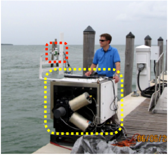
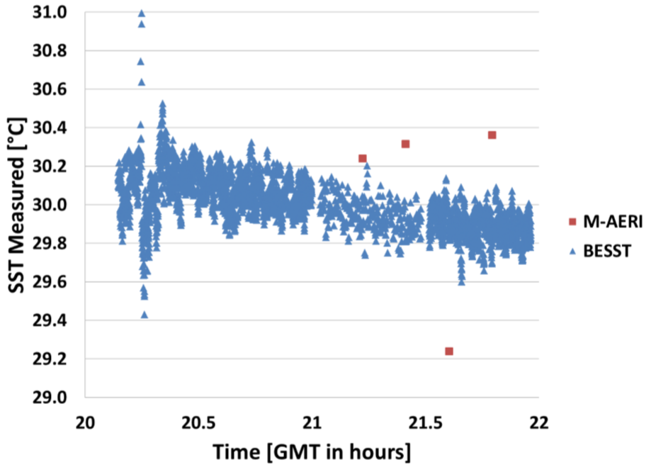
One of our earliest field campaigns was to travel to the University of Florida in Miami to compare it to M-AERI, a NIST-calibrated sea surface temperature instrument. M-AERI is a big, expensive system and we were looking to show BESST performed just as well or better. The next image shows Bill Good standing behind M-AERI (yellow dashed line) with BESST to his right (red dashed line). Both instruments are looking into the water as it streams under the pier during a tide change.
Typical results from the trials are shown in the next image. BESST captured more samples with generally tighter limits on variability. This data was processed with my predecessor’s Matlab code that I subsequently streamlined and updated.
Over the years, we flew with this over places like Salt Lake, Lake Powell, the Arctic, and the Deepwater oil spill in the Gulf of Mexico. We also took advantage of its small size to fly campaigns of opportunity with larger instruments such as lidar.
The Arctic campaign was interesting because the UAV operator crashed his plane on take-off and beat everything up. It took some creativity to get it all working again. My first flight was also interesting because I was trying to get the keyboard script to limp along. (I hadn’t yet written the C# replacement.) I needed to change the script, but the keyboard I was provided stopped working. We were already in the air and couldn’t land. We were bouncing around in a Twin Otter with a hole in the floor and time was ticking. I had to update the code by using a trackball to copy and paste single letters from various text documents into the script to spell the couple of dozen words I needed. It worked and we managed to get great data.
One of the great things about working with a university is the wonderful researchers who take data from our instruments to create scientific insights. For instance, Dr. Sandra Castro did great work with the Arctic data. She used MODIS satellite data from overpasses coincident with BESST’s flight path to show how BESST matches the spatial resolution of space systems while extending it to finer resolutions. This is useful, for instance, for studying smaller currents at the submesoscale level.
The next image comes from a paper Dr. Castro wrote and I supported. It shows the temperature data for BESST and MODIS as a function of time, with the various colors representing longitudes we flew along over the water.
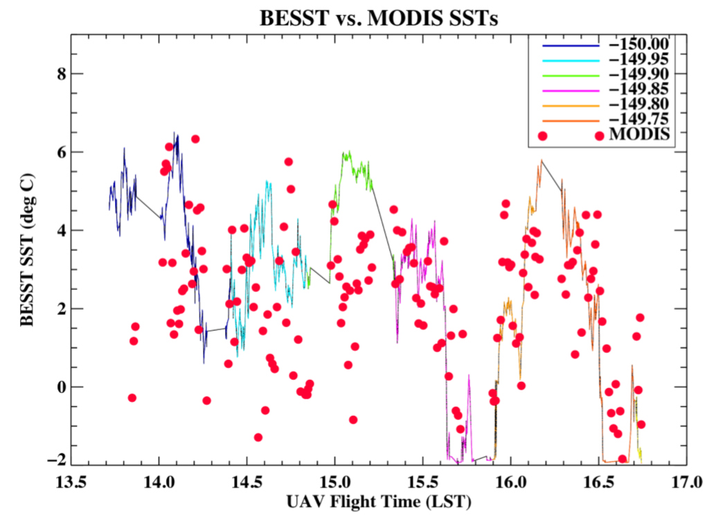
There were challenges in retrieving data because the onboard Inertial Measurement Unit (IMU) had trouble locking onto GPS at the high latitudes. For whatever reason, when it couldn’t lock GPS, it lost the ability to keep accurate time, position, and even orientation. (Ball had no role in selecting the IMU or we would have gone with a higher end version, such as an Applanix.) I spent considerable time backing out errors, interpolating, and correcting navigation issues. I then applied these corrections to calibrated temperature data to provide Sandra the data she needed to perform her higher-level work.
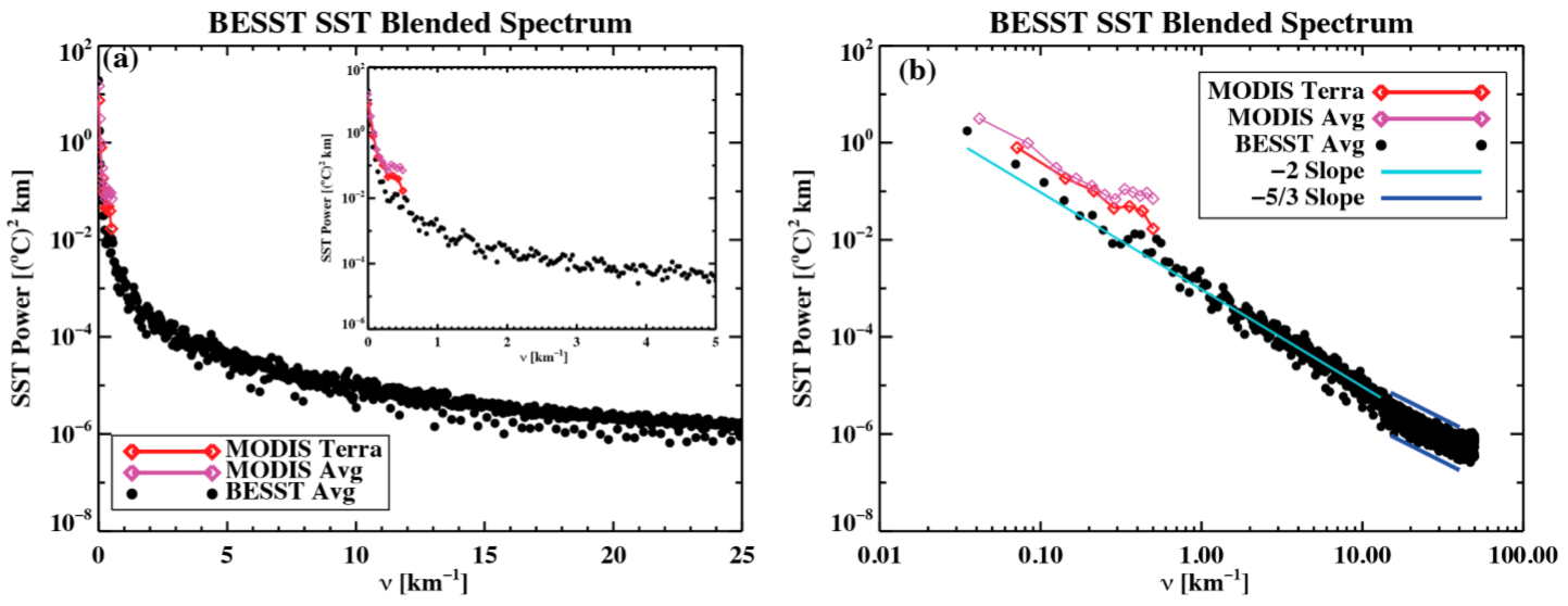
She was able to show results like those in the next image. Here, the wavenumbers (inverse of kilometers) of BESST and MODIS overlap at wavenumbers MODIS can observe, and then BESST continues to map the higher values (shorter lengths).
CIRiS
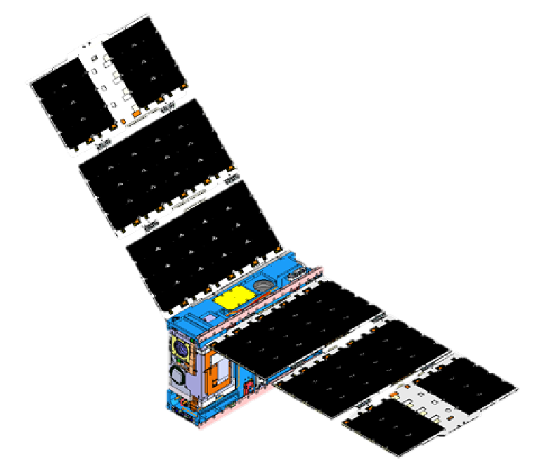
CIRiS is the “Compact Infrared Radiometer in Space). It’s a CubeSat wrapped around a modified version of BESST. The image below shows the deployed system.
Dr. Osterman is the Principal Investigator for this program. He initially invited me to help him with the microbolometer. Tasks involved running lab tests and data analysis to downselect the flight array, the operation mode, and various settings. As I had time, I supported TVAC tests by writing and implementing test procedures. I also wrote some autonomous analysis scripts and mentored a junior engineer. One of the fun things about this program was the very small team; if you were willing to do something, it didn’t matter what your job title or seniority was. We also got to etch our initials into an aluminum inner panel of the bus. Somewhere in orbit is a system floating around earth that I wrote my name into.
Publications
Three publications showing BESST, its science potential, and CIRiS:
Final Thoughts
BESST was my introduction into the larger world of aerospace. I had worked research projects at Ball, but only as a structural engineer. However, once word got out that I could program, wire, integrate, and field test systems, researchers began to seek me out. It became a juggling act to lead large scale structural projects while also doing things like writing embedded C-code and testing antennas. I loved it!
It was also my introduction to Dr. Emery, who would become my PhD advisor several years later. I joined his group to pursue my degree in Aerospace Remote Sensing so that I could build a stronger science and sensing foundation. I wanted (and still want) to build the best, most cutting-edge space systems. BESST was a big part of putting me on this path and breaking me free from a single discipline career.